• World’s human migration patterns in 2000–2019 unveiled by high-resolution data

    Despite being a topical issue in public debate and on the political agenda for many countries, a global-scale, high-resolution quantification of migration and its major drivers for the recent decades remained missing. We created a global dataset of annual net migration between 2000 and 2019 (~10 km grid, covering the areas of 216 countries or sovereign states), based on reported and downscaled subnational birth (2,555 administrative units) and death (2,067 administrative units) rates. We show that, globally, around 50% of the world’s urban population lived in areas where migration accelerated urban population growth, while a third of the global population lived in provinces where rural areas experienced positive net migration. Finally, we show that, globally, socioeconomic factors are more strongly associated with migration patterns than climatic factors. While our method is dependent on census data, incurring notable uncertainties in regions where census data coverage or quality is low, we were able to capture migration patterns not only between but also within countries, as well as by socioeconomic and geophysical zonings. Our results highlight the importance of subnational analysis of migration—a necessity for policy design, international cooperation and shared responsibility for managing internal and international migration.

    https://www.nature.com/articles/s41562-023-01689-4

    La #carte_interactive développée:
    Net migration explorer


    https://vm0803.kaj.pouta.csc.fi/migrationShiny/R

    #données #migrations #cartographie #statistiques #visualisation #facteurs #migration_patterns #push-factors #facteurs_push #facteurs-push #urbanisation #climat #facteurs_climatiques #facteurs_socio-économiques #monde #sans_flèches

    ping @fil @reka

    • Una mappa senza precedenti dei flussi migratori negli ultimi 20 anni

      I fattori socioeconomici sono ancora la ragione principale che spinge le persone a lasciare la propria casa in cerca di condizioni di vita migliori. Questo è quanto emerge dalla mappa più dettagliata mai realizzata finora per ricostruire le migrazioni umane negli ultimi due decenni a livello globale.

      Basandosi su dati provenienti dalle rilevazioni statistiche internazionali e dai censimenti condotti dai singoli paesi, un team internazionale di demografi, geomorfologi, ingegneri ambientali e informatici hanno ricostruito con la più alta risoluzione mai ottenuta finora i flussi migratori a livello sia internazionale che subnazionale per il periodo compreso tra il 2000 e il 2019.

      Il processo di ricostruzione di queste complesse dinamiche demografiche è descritto in una recente pubblicazione su Nature Human Behaviour; gli autori hanno anche sviluppato una mappa interattiva, consultabile liberamente, che permette di distinguere i luoghi che hanno subito una migrazione netta positiva (in cui i tassi di immigrazione superano quelli di emigrazione), e quelli in cui, al contrario, la migrazione netta è negativa (e quindi i tassi di emigrazione superano quelli di immigrazione). Proprio l’alta risoluzione della mappa consente di rilevare differenze significative a livello internazionale, subnazionale e regionale. In Italia, ad esempio, la mappa mostra chiaramente una migrazione netta positiva nelle regioni del Nord e una negativa in quelle meridionali. Lo stesso vale anche per la Francia e il Portogallo (dove le regioni settentrionali sono caratterizzate da una migrazione netta positiva, al contrario di quelle meridionali).

      https://twitter.com/NatureHumBehav/status/1700112207973863647

      “A livello globale, il modello di migrazione più comune si sviluppa dalle aree rurali verso quelle urbane, come indicato dalla migrazione netta urbana positiva e dalla migrazione netta rurale negativa”, spiega Raya Muttarak, professoressa di demografia all’università di Bologna, che ha partecipato allo studio. “L’immigrazione netta positiva può contribuire alla crescita della popolazione urbana invertendo i naturali trend demografici in calo, com’è accaduto in alcuni paesi, tra cui Germania, Austria e Spagna”.

      I ricercatori hanno infatti confermato l’esistenza di una dinamica chiamata “urban pull-rural push” (letteralmente: “attrazione urbana-spinta rurale”) rilevata anche da alcuni studi precedenti sull’argomento, che descrive, sostanzialmente, il fenomeno per cui la migrazione netta nelle aree urbane è tendenzialmente positiva, mentre quella nelle aree rurali è negativa. In altre parole, il numero di persone che lasciano la campagna per trasferirsi in città è maggiore rispetto alla quantità di individui che fanno la scelta opposta. “La situazione “urban pull-rural push” rappresenta il modello migratorio più comune all’interno di quei paesi in cui le città offrono condizioni di vita desiderabili, che attraggono l’immigrazione, al contrario delle zone rurali, le cui caratteristiche spingono i residenti a trasferirsi altrove, in cerca di una vita migliore”, precisa Muttarak.

      Per individuare le ragioni che spiegano i flussi di popolazione a livello sia subnazionale che internazionale, i ricercatori hanno incrociato i dati demografici dei luoghi considerati con i relativi tassi di sviluppo socioeconomico e l’indice di aridità. I risultati di tale confronto mostrano come la migrazione netta positiva sia significativamente più alta nei luoghi caratterizzati da un alto tasso di sviluppo economico, più che da quelli con scarsi livelli di aridità. Sembra, in altre parole, che i migranti ambientali –coloro che lasciano il luogo in cui vivevano a causa dei danni dovuti a eventi climatici estremi (come le ondate di calore, le inondazioni o la siccità) – siano in minoranza rispetto alle persone che emigrano in cerca di migliori prospettive di carriera e stabilità finanziaria.

      Un altro aspetto di cui i ricercatori tengono conto è la valutazione dell’impatto del fenomeno migratorio sulle società di origine e di destinazione. “La mappa consente di analizzare le tendenze e i modelli migratori che a loro volta influenzano le dinamiche demografiche delle aree di partenza e di arrivo dei flussi migratori”, prosegue Muttarak. “È quindi possibile stimare l’impatto socioeconomico e ambientale legato al cambiamento demografico. Abbiamo scoperto che l’immigrazione netta positiva ha contribuito alla crescita della popolazione in particolare nelle aree ad alto tasso di sviluppo umano, suggerendo che le persone tendano maggiormente a trasferirsi verso questi luoghi”. Come scrivono gli autori nello studio, quando si verifica un afflusso consistente di popolazione in aree già densamente popolate, le infrastrutture, le risorse naturali e quelle umane possono essere messe a dura prova. Dall’altro lato, però, come accade in Europa, si abbassa l’età media della forza lavoro.

      In conclusione, in un’epoca come la nostra, in cui le migrazioni umane rappresentano un tema centrale nel dibattito pubblico internazionale, disporre di una mappa globale e ad alta risoluzione dei flussi migratori in tutto il mondo può rivelarsi particolarmente utile per scienziati e decisori politici. “Grazie al livello di granularità geografica dei nuovi dati e alla loro frequenza temporale – ovvero la disponibilità su base annuale – diventa possibile studiare le tendenze migratorie e i fattori che le determinano”, osserva Muttarak. “Ciò consente, ad esempio, di analizzare dettagliatamente come i fattori ambientali e climatici influiscano sulla migrazione a livello geografico. Sulla base delle tendenze migratorie nette diventa possibile anche identificare i punti caldi in cui si concentrano i flussi di popolazione e le aree in fase di declino demografico. Tali intuizioni possono aiutare i politici a elaborare strategie per la pianificazione urbana e lo sviluppo rurale”.

      https://ilbolive.unipd.it/it/news/mappa-senza-precedenti-flussi-migratori-ultimi-20

  • Les cartes sont-elles « objectives » ?

    Alors que des milliards de milliards de données sont créées sans cesse sur tout, l’ensemble du territoire n’est aujourd’hui pas entièrement cartographié. Que signifient la présence de blancs dans les cartes ? Quels en sont les enjeux de #pouvoir ?

    Tout part de l’observation de cartes anciennes qui représentent des contrées mal connues par les cartographes européens. L’Afrique, L’Amérique latine, dont a vient juste de découvrir les côtes. Dans les espaces encore inconnus, on laisse de larges #espaces_blancs, agrémentés d’animaux exotiques qu’on imagine se trouver là : des tigres, des éléphants, de petites montagnes stylisés ou des humains représentés sous une forme exotique. Il y a comme une part de rêve dans ce qui n’est pas représenté par la carte : le #vide semble nous raconter plus d’histoire que le plein et nous dire : « il était une fois, dans une contrée très éloignée... ». D’ailleurs les informations dessinées dans le blanc des cartes étaient imaginaires, c’était une époque où la géographie avait à voir avec la fiction. Ce #blanc_des_cartes avait un effet puissant sur l’imagination des explorateurs…

    https://www.radiofrance.fr/franceculture/podcasts/geographie-a-la-carte/les-cartes-sont-elles-objectives-6785331
    #audio #podcast #cartographie #objectivité #Matthieu_Noucher #géographie_du_vide #imaginaire #imagination #blanc

    ping @visionscarto

    –—

    Voir aussi :
    Blancs des cartes et boîtes noires algorithmiques


    https://seenthis.net/messages/1004355
    #livre

  • The State of #Chihuahua Is Building a 20-Story Tower in #Ciudad_Juarez to Surveil 13 Cities–and Texas Will Also Be Watching

    Chihuahua state officials and a notorious Mexican security contractor broke ground last summer on the #Torre_Centinela (Sentinel Tower), an ominous, 20-story high-rise in downtown Ciudad Juarez that will serve as the central node of a new AI-enhanced surveillance regime. With tentacles reaching into 13 Mexican cities and a data pipeline that will channel intelligence all the way to Austin, Texas, the monstrous project will be unlike anything seen before along the U.S.-Mexico border.

    And that’s saying a lot, considering the last 30-plus years of surging technology on the U.S side of the border.

    The Torre Centinela will stand in a former parking lot next to the city’s famous bullring, a mere half-mile south of where migrants and asylum seekers have camped and protested at the Paso del Norte International Bridge leading to El Paso. But its reach goes much further: the Torre Centinela is just one piece of the Plataforma Centinela (Sentinel Platform), an aggressive new technology strategy developed by Chihuahua’s Secretaria de Seguridad Pública Estatal (Secretary of State Public Security or SSPE) in collaboration with the company Seguritech.

    With its sprawling infrastructure, the Plataforma Centinela will create an atmosphere of surveillance and data-streams blanketing the entire region. The plan calls for nearly every cutting-edge technology system marketed at law enforcement: 10,000 surveillance cameras, face recognition, automated license plate recognition, real-time crime analytics, a fleet of mobile surveillance vehicles, drone teams and counter-drone teams, and more.

    If the project comes together as advertised in the Avengers-style trailer that SSPE released to influence public opinion, law enforcement personnel on site will be surrounded by wall-to-wall monitors (140 meters of screens per floor), while 2,000 officers in the field will be able to access live intelligence through handheld tablets.

    https://www.youtube.com/watch?v=NKPuur6s4qg

    Texas law enforcement will also have “eyes on this side of the border” via the Plataforma Centinela, Chihuahua Governor Maru Campos publicly stated last year. Texas Governor Greg Abbott signed a memorandum of understanding confirming the partnership.

    Plataforma Centinela will transform public life and threaten human rights in the borderlands in ways that aren’t easy to assess. Regional newspapers and local advocates–especially Norte Digital and Frente Político Ciudadano para la Defensa de los Derechos Humanos (FPCDDH)—have raised significant concerns about the project, pointing to a low likelihood of success and high potential for waste and abuse.

    “It is a myopic approach to security; the full emphasis is placed on situational prevention, while the social causes of crime and violence are not addressed,” FPCDDH member and analyst Victor M. Quintana tells EFF, noting that the Plataforma Centinela’s budget is significantly higher than what the state devotes to social services. “There are no strategies for the prevention of addiction, neither for rebuilding the fabric of society nor attending to dropouts from school or young people at risk, which are social causes of insecurity.”

    Instead of providing access to unfiltered information about the project, the State of Chihuahua has launched a public relations blitz. In addition to press conferences and the highly-produced cinematic trailer, SSPE recently hosted a “Pabellón Centinel” (Sentinel Pavillion), a family-friendly carnival where the public was invited to check out a camera wall and drones, while children played with paintball guns, drove a toy ATV patrol vehicle around a model city, and colored in illustrations of a data center operator.

    Behind that smoke screen, state officials are doing almost everything they can to control the narrative around the project and avoid public scrutiny.

    According to news reports, the SSPE and the Secretaría de Hacienda (Finance Secretary) have simultaneously deemed most information about the project as classified and left dozens of public records requests unanswered. The Chihuahua State Congress also rejected a proposal to formally declassify the documents and stymied other oversight measures, including a proposed audit. Meanwhile, EFF has submitted public records requests to several Texas agencies and all have claimed they have no records related to the Plataforma Centinela.

    This is all the more troubling considering the relationship between the state and Seguritech, a company whose business practices in 22 other jurisdictions have been called into question by public officials.

    What we can be sure of is that the Plataforma Centinela project may serve as proof of concept of the kind of panopticon surveillance governments can get away with in both North America and Latin America.
    What Is the Plataforma Centinela?

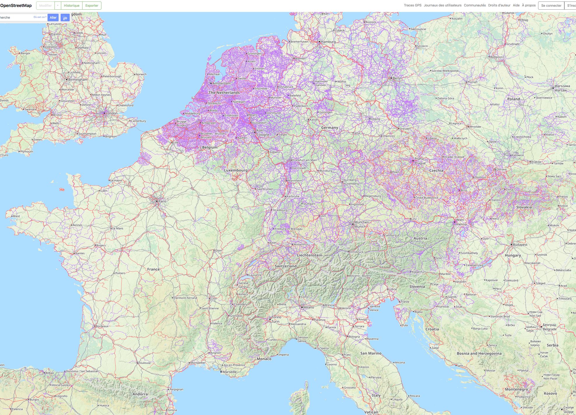
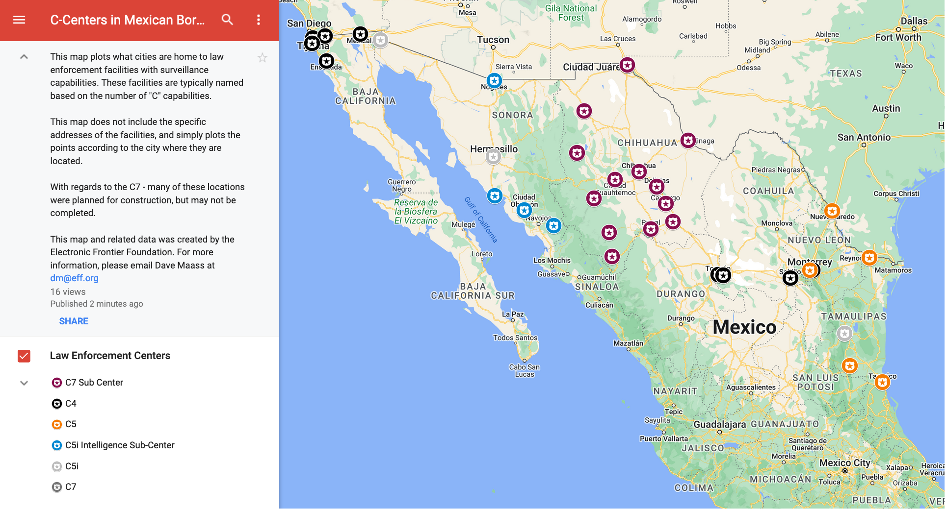
    High-tech surveillance centers are not a new phenomenon on the Mexican side of the border. These facilities tend to use “C” distinctions to explain their functions and purposes. EFF has mapped out dozens of these in the six Mexican border states.

    https://www.eff.org/files/2023/09/14/c-centers_map.png
    https://www.google.com/maps/d/viewer?mid=1W73dMXnuXvPl5cSRGfi1x-BQAEivJH4&ll=25.210543464111723%2C-105.379

    They include:

    - C4 (Centro de Comunicación, Cómputo, Control y Comando) (Center for Communications, Calculation, Control, and Command),
    - C5 (Centro de Coordinación Integral, de Control, Comando, Comunicación y Cómputo del Estado) (Center for Integral Coordination for Control, Command, Communications, and State Calculation),
    - C5i (Centro de Control, Comando, Comunicación, Cómputo, Coordinación e Inteligencia) (Center for Control, Command, Communication, Calculation, Coordination and Intelligence).

    Typically, these centers focus as a cross between a 911 call center and a real-time crime center, with operators handling emergency calls, analyzing crime data, and controlling a network of surveillance cameras via a wall bank of monitors. In some cases, the Cs may be presented in different order or stand for slightly different words. For example, some C5s might alternately stand for “Centros de Comando, Control, Comunicación, Cómputo y Calidad” (Centers for Command, Control, Communication, Computation and Quality). These facilities also exist in other parts of Mexico. The number of Cs often indicate scale and responsibilities, but more often than not, it seems to be a political or marketing designation.

    The Plataforma Centinela however, goes far beyond the scope of previous projects and in fact will be known as the first C7 (Centro de Comando, Cómputo, Control, Coordinación, Contacto Ciudadano, Calidad, Comunicaciones e Inteligencia Artificial) (Center for Command, Calculation, Control, Coordination, Citizen Contact, Quality, Communications and Artificial Intelligence). The Torre Centinela in Ciudad Juarez will serve as the nerve center, with more than a dozen sub-centers throughout the state.

    According to statistics that Gov. Campos disclosed as part of negotiations with Texas and news reports, the Plataforma Centinela will include:

    - 1,791 automated license plate readers. These are cameras that photograph vehicles and their license plates, then upload that data along with the time and location where the vehicles were seen to a massive searchable database. Law enforcement can also create lists of license plates to track specific vehicles and receive alerts when those vehicles are seen.
    - 4,800 fixed cameras. These are your run-of-the-mill cameras, positioned to permanently surveil a particular location from one angle.
    - 3,065 pan-tilt-zoom (PTZ) cameras. These are more sophisticated cameras. While they are affixed to a specific location, such as a street light or a telephone pole, these cameras can be controlled remotely. An operator can swivel the camera around 360-degrees and zoom in on subjects.
    - 2,000 tablets. Officers in the field will be issued handheld devices for accessing data directly from the Plataforma Centinela.
    - 102 security arches. This is a common form of surveillance in Mexico, but not the United States. These are structures built over highways and roads to capture data on passing vehicles and their passengers.
    - 74 drones (Unmanned Aerial Vehicles/UAVs). While the Chihuahua government has not disclosed what surveillance payload will be attached to these drones, it is common for law enforcement drones to deploy video, infrared, and thermal imaging technology.
    - 40 mobile video surveillance trailers. While details on these systems are scant, it is likely these are camera towers that can be towed to and parked at targeted locations.
    - 15 anti-drone systems. These systems are designed to intercept and disable drones operated by criminal organizations.
    - Face recognition. The project calls for the application of “biometric filters” to be applied to camera feeds “to assist in the capture of cartel leaders,” and the collection of migrant biometrics. Such a system would require scanning the faces of the general public.
    - Artificial intelligence. So far, the administration has thrown around the term AI without fully explaining how it will be used. However, typically law enforcement agencies have used this technology to “predict” where crime might occur, identify individuals mostly likely to be connected to crime, and to surface potential connections between suspects that would not have been obvious to a human observer. However, all these technologies have a propensity for making errors or exacerbating existing bias.

    As of May, 60% of the Plataforma Centinela camera network had been installed, with an expected completion date of December, according to Norte Digital. However, the cameras were already being used in criminal investigations.

    All combined, this technology amounts to an unprecedented expansion of the surveillance state in Latin America, as SSPE brags in its promotional material. The threat to privacy may also be unprecedented: creating cities where people can no longer move freely in their communities without being watched, scanned, and tagged.

    But that’s assuming the system functions as advertised—and based on the main contractor’s history, that’s anything but guaranteed.
    Who Is Seguritech?

    The Plataforma Centinela project is being built by the megacorporation Seguritech, which has signed deals with more than a dozen government entities throughout Mexico. As of 2018, the company received no-bid contracts in at least 10 Mexican states and cities, which means it was able to sidestep the accountability process that requires companies to compete for projects.

    And when it comes to the Plataforma Centinela, the company isn’t simply a contractor: It will actually have ownership over the project, the Torre Centinela, and all its related assets, including cameras and drones, until August 2027.

    That’s what SSPE Secretary Gilberto Loya Chávez told the news organization Norte Digital, but the terms of the agreement between Seguritech and Chihuahua’s administration are not public. The SSPE’s Transparency Committee decided to classify the information “concerning the procedures for the acquisition of supplies, goods, and technology necessary for the development, implementation, and operation of the Platforma Centinela” for five years.

    In spite of the opacity shrouding the project, journalists have surfaced some information about the investment plan. According to statements from government officials, the Plataforma Centinela will cost 4.2 billion pesos, with Chihuahua’s administration paying regular installments to the company every three months (Chihuahua’s governor had previously said that these would be yearly payments in the amount of 700 million to 1 billion pesos per year). According to news reports, when the payments are completed in 2027, the ownership of the platform’s assets and infrastructure are expected to pass from Seguritech to the state of Chihuahua.

    The Plataforma Centinela project marks a new pinnacle in Seguritech’s trajectory as a Mexican security contractor. Founded in 1995 as a small business selling neighborhood alarms, SeguriTech Privada S.A de C.V. became a highly profitable brand, and currently operates in five areas: security, defense, telecommunications, aeronautics, and construction. According to Zeta Tijuana, Seguritech also secures contracts through its affiliated companies, including Comunicación Segura (focused on telecommunications and security) and Picorp S.A. de C.V. (focused on architecture and construction, including prisons and detention centers). Zeta also identified another SecuriTech company, Tres10 de C.V., as the contractor named in various C5i projects.

    Thorough reporting by Mexican outlets such as Proceso, Zeta Tijuana, Norte Digital, and Zona Free paint an unsettling picture of Seguritech’s activities over the years.

    Former President Felipe Calderón’s war on drug trafficking, initiated during his 2006-2012 term, marked an important turning point for surveillance in Mexico. As Proceso reported, Seguritech began to secure major government contracts beginning in 2007, receiving its first billion-peso deal in 2011 with Sinaloa’s state government. In 2013, avoiding the bidding process, the company secured a 6-billion peso contract assigned by Eruviel Ávila, then governor of the state of México (or Edomex, not to be confused with the country of Mexico). During Enrique Peña Nieto’s years as Edomex’s governor, and especially later, as Mexico’s president, Seguritech secured its status among Mexico’s top technology contractors.

    According to Zeta Tijuana, during the six years that Peña Nieto served as president (2012-2018), the company monopolized contracts for the country’s main surveillance and intelligence projects, specifically the C5i centers. As Zeta Tijuana writes:

    “More than 10 C5i units were opened or began construction during Peña Nieto’s six-year term. Federal entities committed budgets in the millions, amid opacity, violating parliamentary processes and administrative requirements. The purchase of obsolete technological equipment was authorized at an overpriced rate, hiding information under the pretext of protecting national security.”

    Zeta Tijuana further cites records from the Mexican Institute of Industrial Property showing that Seguritech registered the term “C5i” as its own brand, an apparent attempt to make it more difficult for other surveillance contractors to provide services under that name to the government.

    Despite promises from government officials that these huge investments in surveillance would improve public safety, the country’s number of violent deaths increased during Peña Nieto’s term in office.

    “What is most shocking is how ineffective Seguritech’s system is,” says Quintana, the spokesperson for FPCDDH. By his analysis, Quintana says, “In five out of six states where Seguritech entered into contracts and provided security services, the annual crime rate shot up in proportions ranging from 11% to 85%.”

    Seguritech has also been criticized for inflated prices, technical failures, and deploying obsolete equipment. According to Norte Digital, only 17% of surveillance cameras were working by the end of the company’s contract with Sinaloa’s state government. Proceso notes the rise of complaints about the malfunctioning of cameras in Cuauhtémoc Delegation (a borough of Mexico City) in 2016. Zeta Tijuana reported on the disproportionate amount the company charged for installing 200 obsolete 2-megapixel cameras in 2018.

    Seguritech’s track record led to formal complaints and judicial cases against the company. The company has responded to this negative attention by hiring services to take down and censor critical stories about its activities published online, according to investigative reports published as part of the Global Investigative Journalism Network’s Forbidden Stories project.

    Yet, none of this information dissuaded Chihuahua’s governor, Maru Campos, from closing a new no-bid contract with Seguritech to develop the Plataforma Centinela project.
    A Cross-Border Collaboration

    The Plataforma Centinela project presents a troubling escalation in cross-border partnerships between states, one that cuts out each nation’s respective federal governments. In April 2022, the states of Texas and Chihuahua signed a memorandum of understanding to collaborate on reducing “cartels’ human trafficking and smuggling of deadly fentanyl and other drugs” and to “stop the flow of migrants from over 100 countries who illegally enter Texas through Chihuahua.”
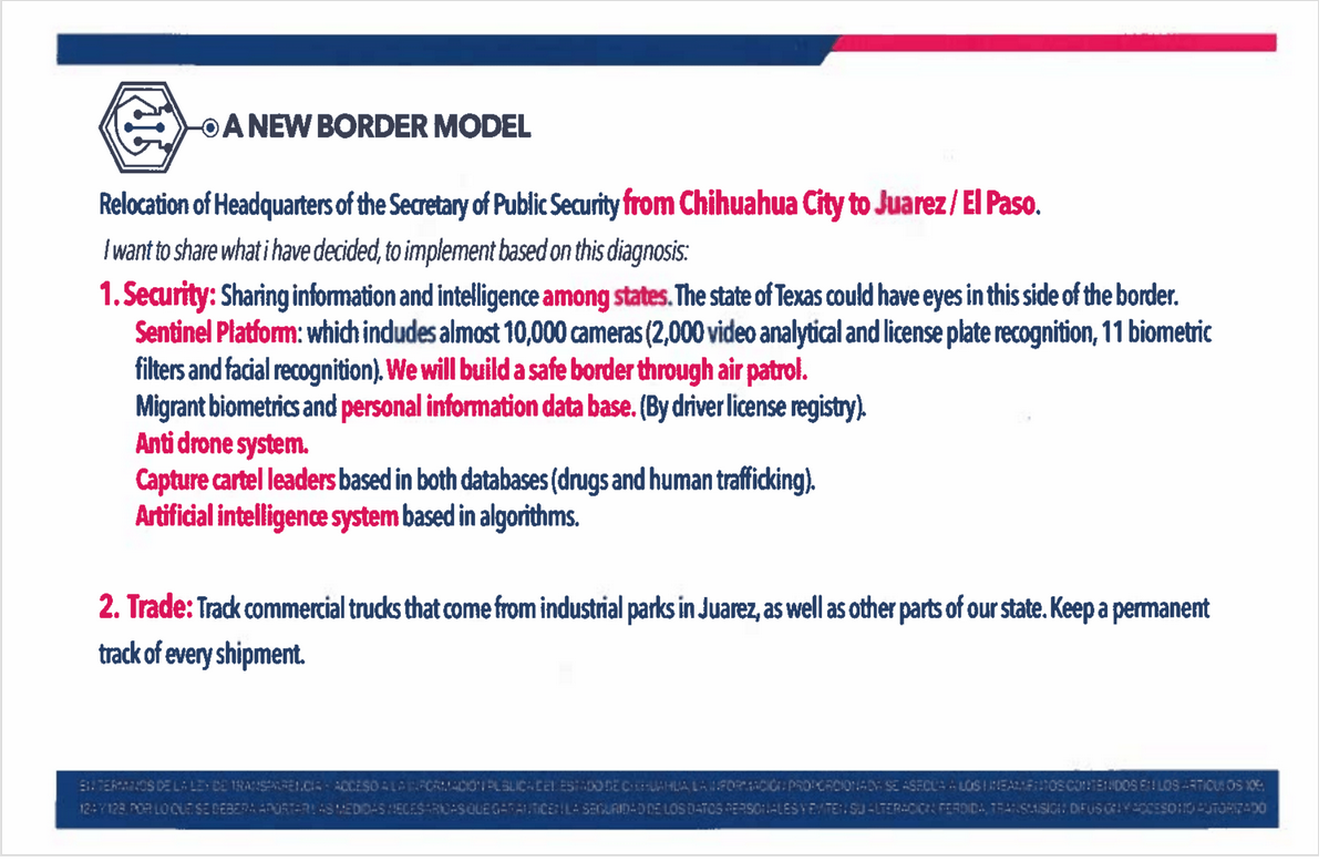
    https://www.eff.org/files/2023/09/14/a_new_border_model.png

    While much of the agreement centers around cargo at the points of entry, the document also specifically calls out the various technologies that make up the Plataforma Centinela. In attachments to the agreement, Gov. Campos promises Chihuahua is “willing to share that information with Texas State authorities and commercial partners directly.”

    During a press conference announcing the MOU, Gov. Abbot declared, “Governor Campos has provided me with the best border security plan that I have seen from any governor from Mexico.” He held up a three-page outline and a slide, which were also provided to the public, but also referenced the existence of “a much more extensive detailed memo that explains in nuance” all the aspects of the program.

    Abbott went on to read out a summary of Plataforma Centinela, adding, “This is a demonstration of commitment from a strong governor who is working collaboratively with the state of Texas.”

    Then Campos, in response to a reporter’s question, added: “We are talking about sharing information and intelligence among states, which means the state of Texas will have eyes on this side of the border.” She added that the data collected through the Plataforma Centinela will be analyzed by both the states of Chihuahua and Texas.

    Abbott provided an example of one way the collaboration will work: “We will identify hotspots where there will be an increase in the number of migrants showing up because it’s a location chosen by cartels to try to put people across the border at that particular location. The Chihuahua officials will work in collaboration with the Texas Department of Public Safety, where DPS has identified that hotspot and the Chihuahua side will work from a law enforcement side to disrupt that hotspot.”

    In order to learn more about the scope of the project, EFF sent public records requests to several Texas agencies, including the Governor’s Office, the Texas Department of Public Safety, the Texas Attorney General’s Office, the El Paso County Sheriff, and the El Paso Police Department. Not one of the agencies produced records related to the Plataforma Centinela project.

    Meanwhile, Texas is further beefing up its efforts to use technology at the border, including by enacting new laws that formally allow the Texas National Guard and State Guard to deploy drones at the border and authorize the governor to enter compacts with other states to share intelligence and resource to build “a comprehensive technological surveillance system” on state land to deter illegal activity at the border. In addition to the MOU with Chihuahua, Abbott also signed similar agreements with the states of Nuevo León and Coahuila in 2022.
    Two Sides, One Border

    The Plataforma Centinela has enormous potential to violate the rights of one of the largest cross-border populations along the U.S.-Mexico border. But while law enforcement officials are eager to collaborate and traffic data back and forth, advocacy efforts around surveillance too often are confined to their respective sides.

    The Spanish-language press in Mexico has devoted significant resources to investigating the Plataforma Centinela and raising the alarm over its lack of transparency and accountability, as well as its potential for corruption. Yet, the project has received virtually no attention or scrutiny in the United States.

    Fighting back against surveillance of cross-border communities requires cross-border efforts. EFF supports the efforts of advocacy groups in Ciudad Juarez and other regions of Chihuahua to expose the mistakes the Chihuahua government is making with the Plataforma Centinela and call out its mammoth surveillance approach for failing to address the root social issues. We also salute the efforts by local journalists to hold the government accountable. However, U.S-based journalists, activists, and policymakers—many of whom have done an excellent job surfacing criticism of Customs and Border Protection’s so-called virtual wall—must also turn their attention to the massive surveillance that is building up on the Mexican side.

    In reality, there really is no Mexican surveillance and U.S. surveillance. It’s one massive surveillance monster that, ironically, in the name of border enforcement, recognizes no borders itself.

    https://www.eff.org/deeplinks/2023/09/state-chihuahua-building-20-story-tower-ciudad-juarez-surveil-13-cities-and-sta
    #surveillance #tour #surveillance_de_masse #cartographie #visualisation #intelligence_artificielle #AI #IA #frontières #contrôles_frontaliers #technologie #Plataforma_Centinela #données #reconnaissance_faciale #caméras_de_surveillance #drones #Seguritech #complexe_militaro-industriel #Mexique

  • Reinhold Messner Rekord aberkannt : Frechheit
    https://www.nd-aktuell.de/artikel/1176592.personalie-eberhard-jurgalski-reinhold-messner-rekord-aberkannt-f

    L’alpiniste le plus célèbre d’Allemagne et d’Autriche Messner vient de perdre le titre du premier homme qui a escaladé sans bouteille d’oxygène les quatre plus haut sommets du monde. Tant pis, cet honneur revient désormais à un amerloque aussi taré que notre héro italien par son passport et allemand dans nos coeurs. Une gentiile dame qui l’a accompgné vient de perdre son record aussi, mais je ne saurais me prononcer sur l’impact de cette histoire du côté féminin.

    L’ironie de l’histoire est le personnage à l’origine du dévoilement des records factices : c’est un cartographe un peu trop précis qui passe tout son temps libre avec la vérification des lieux et indications d’hauteur des exploits alpinistes. Il n’a jamais voyagé dans les Alpes et n’a surtout jamais escaladé le moindre sommet digne de cette appellation.

    26.9.2023 von Christin Odoj - Der Himalaya-Experte Eberhard Jurgalski hat nachgerechnet: Reinhold Messner war nicht der Erste.

    Alle paar Hundert Jahre kommt es vor, dass pedantische Wissenschaftler scheinbar Feststehendes infrage stellen und damit für Streit sorgen. Bestes Beispiel: Galileo Galilei. Der moderne Galilei heißt Eberhard Jurgalski und ist Himalaya-Experte. Er hat es nach zehn Jahren akribischer Forschung geschafft, anhand von gesammelten Geodaten dem Extrembergsteiger und Extrem-alles Reinhold Messner seinen Weltrekord abzuerkennen. Messner ist nicht länger der Mensch, der als erster alle Achttausender bestiegen hat. Jurgalski ist in der Bergsteiger-Community ungefähr so beliebt, wie Galilei es bei der Kirche war. Denn der 1952 im brutal flachen Salzgitter geborene Zahlenfetischist hat bewiesen, dass Messner nie auf dem Gipfel der Annapurna (8091 Meter) stand, sondern 65 Meter davor und fünf Höhenmeter darunter. Tatsächlich ist es bei vielen Bergen schwer ersichtlich, wo genau der Gipfel liegt. Jugalski hat die Sache nun mit Hilfe von Geodaten des Deutschen Zentrums für Luft- und Raumfahrt und Fotos aufgedeckt. Im neuen Guinessbuch der Rekorde steht jetzt der US-Amerikaner Ed Viesturs als Rekordhalter. Messner ist außer sich vor Wut auf den Mann, der in seinem kleinen Büro in Lörrach (immerhin 294 Meter über null) das Erbe vieler Säulenheiliger des Alpinismus infrage stellt, der aber selbst noch nie im Himalaya war und dessen höchste Gipfelbesteigung der Tüllinger Berg (460 Meter) bei Lörrach gewesen ist.

    Jurgalski arbeitet seit mehr als 40 Jahren an seiner Bergchronik und hat bereits diversen anderen Bergsteiger*innen ihre Gipfelerfolge weggerechnet. Seine Leidenschaft fürs Rechthaben entdeckte er im Erdkunde-Unterricht. Es störte ihn, dass in verschiedenen Atlanten dieselben Berge unterschiedlich hoch waren. Bei dem Gegockel geht der spannendste Aspekt jedoch unter: Mit Messner verliert auch Gerlinde Kaltenbrunner ihren Rekord, die erste (und bisher einzige) Frau auf allen 8000ern ohne Flaschensauerstoff gewesen zu sein. Auf geht’s, Ladys, Geschichte wird gemacht.

    #alpinisme #cartographie #record_mondial #wtf

  • #Geovelo

    Objectif du gouvernement français : devenir la destination cyclotouristique numéro 1 au monde d’ici 2030. 💚

    Cette carte a été générée grâce aux 50 000 voyages réalisés cet été avec Geovelo, mettant ainsi en lumière le vaste réseau de #véloroutes en France.

    https://twitter.com/geovelofr/status/1704763826401341672

    #Geovélo #vélo #cartographie #visualisation #itinéraires_cyclables #cyclotourisme #app

    • J’ai une posture par rapport au cyclotourisme que j’ai du mal à déconstruire et dont j’ai du mal à me défaire : j’oppose le cyclotourisme au vélo de déplacement. Certains diraient « commute », « faire ses courses », « remplacer la voiture »...
      Je vois bien passer dans le suivi de l’ADAV (une asso vélo par chez moi), ces projets cyclotouristiques : véloroutes, axes verts...
      Mais même si je suis très content que de l’argent soit mis dans le vélo, je trouve que ça l’accapare loin des villes et surtout loin des agglomérations, qui sont mal traitées et qui pourtant appellent à corps et à cri des efforts de restructurations dans les banlieux française, en terme de cyclabilité. Qu’on nous permettre de contre balancer ce qui s’y trouve etre une gene pour le cycle : les axes autoroutiers, les ponds routiers, les MIN, les axes 70... tous ces trucs d’un autre temps qui sont des freins au développement du vélo en banlieue.
      Alors c’est peut être transitoire et ca viendra.
      Mais ces 10 dernières années les efforts se sont porté sur les centres ville. A présent sur la rase campagne « touristiquement interessante ». Mais l’entre deux est négligé, à mes yeux.

      Donc je n’applaudis que faiblement.

    • Je suis d’accord avec toi, @sandburg, j’ai le même malaise, alors qu’en réalité l’un ne devrait pas exclure l’autre : construire des infrastructures pour le « cyclotourisme », mais aussi des infrastructures pour le vélo de tous les jours, dans les centres-villes comme dans les banlieues...

  • The Project : Sound like Donauinsel

    With this blog post and sound map of the Donauinsel in Vienna, we tried to capture place-specific acoustic features along a roughly 500m interval transect across the whole island. On May 20th, 2023, we walked the island from the north-western to the south-eastern end and took 2 minute long recordings at every stop. The recording took place at noon and afternoon on a warm and sunny Saturday. However, due to heavy rains in the days and weeks before that date, resulting in higher water-levels as well as low water temperatures, the island was less populated than it normally would have been in late spring and summer weekends. By clicking on the points on the map you can see the name of the recording and find it in the playlist below. The playlist will also play the sounds from north to south automatically in the background as well. The way urban soundscapes can be studied are manifold. With this blog we first want to present the recordings as they are, simply to be listened to, without any analysis of the sound data itself for now. However, we understand this as a first step in an exploratory process to capturing and analysing urban soundscapes in Vienna. Important considerations include comparative analyses of sound data at different day and night times as well as seasonal variation in relation to not only how different places can sound in terms of volumes and frequencies, but also how people sense and react to different soundscapes at different times.

    https://soundslikedonauinsel.blogspot.com

    #son #bruit #villes #urbanisme #urban_matter #soundscape #Vienna #Vienne #Donauinsel #soundmap #cartographie #visualisation

    ping @reka

  • Mann stirbt bei Brückensturz : Familie verklagt Google Maps wegen falscher Navigation
    https://www.berliner-zeitung.de/news/mann-stuerzt-von-bruecke-familie-verklagt-google-wegen-navigation-l

    Voilà ce qui t’arrive si tu fais confiance à la cartographie élaborée par les monopoles. Tu meurs. D’une manière ou d’une autre. C’est aussi simple que ça.

    Peut-être c’est moins grave dans un monde meilleur où les représentations cartographiques ne sont pas faussées par les cartographes sous contrat chez les maîtres du monde. Là où l’état s’occupe bien des infrastructures.

    Dans le monde fabuleux de l’entreprise libre style USA il ne faut faire confiance qu’à ses amis et alliés - mais pas trop quand même, sachant qu’eux aussi sont victimes des faussaires.

    Eine Familie in North Carolina in den USA hat Google verklagt. Ein Familienmitglied sei der Navigation von Google Maps gefolgt und mit dem Auto über eine eingestürzte Brücke gefahren, wie das Nachrichtenmagazin Spiegel berichtet. Die Familie wirft Google vor, von der Baufälligkeit der Brücke gewusst zu haben und fahrlässig gehandelt zu haben. Google habe es versäumt, sein Navigationssystem zu aktualisieren, heißt es.

    Die Brücke sei demnach bereits vor neun Jahren eingestürzt. Trotzdem fehlten laut der North Carolina State Patrol Warnhinweise an der Straße. Die Brücke sei weder von lokalen noch von staatlichen Stellen gewartet worden.
    Mann folgt Google Maps und stürzt mit dem Auto von einer Brücke

    Wie aus der Klageschrift hervorgeht, war der Vater von zwei Kindern am 30. September 2022 auf der Strecke unterwegs gewesen und stürzte sechs Meter tief von der Brücke in einen Fluss, wo er ertrank.

    Beklagt wird demnach, dass Google zuvor bereits mehrere Male von Personen über den maroden Zustand der Brücke informiert worden war. Dennoch seien die Routeninformationen nicht aktualisiert worden. Google hat zu dem Vorfall bislang noch keine Stellung bezogen.

    #cartographie_fatale #USA #Google #Alphabet_Inc #droit #infrastructure_publiqe

  • Julia Cagé et Thomas Piketty livrent une vision inédite de l’histoire politique française
    https://www.lemonde.fr/idees/article/2023/09/05/julia-cage-et-thomas-piketty-livrent-une-vision-inedite-de-l-histoire-politi

    Dans « Une histoire du conflit politique », les économistes publient une somme sur l’histoire électorale de la France. En fonction des revenus, du milieu social et du lieu d’habitation des votants, ils analysent les rapports de force – bipartition ou tripartition – qui dominent le champ politique et leurs liens avec les inégalités sociales.

    La classe géosociale

    Mais comment fait-on pour savoir qui vote pour qui ? A cette question centrale, les auteurs ne peuvent s’appuyer que sur des informations électorales à l’échelon des communes – ce qui implique un niveau territorial et non individuel. Ils ne bénéficient pas, en effet, d’études d’opinions avant les années 1950. D’où la nécessité, de l’aveu même des auteurs, de redoubler de prudence quant aux interprétations, mais aussi de trouver une autre base de référence : la classe géosociale.

    Grâce à l’usage systématique de cette notion, les deux économistes arrivent à des conclusions fortes qui viennent contredire les débats politiques actuels. Ils expliquent notamment que les variables liées à la religion et aux origines étrangères ont beaucoup moins d’importance que celles liées à la classe géosociale. « Autrement dit, ce sont bien les enjeux socio-économiques – et non les questions identitaires ou la proportion d’étrangers – qui déterminent les clivages électoraux. » Ces résultats sont valables pour les scrutins présidentiels de 1848, mais aussi de 1965 à 2022, malgré l’omniprésence de ces thèmes dans le débat public.

    Les auteurs proposent aussi une chronologie originale de deux cent trente ans de vie politique française. Celle-ci a connu, expliquent-ils, des périodes de « bipolarisation » et de « tripartition ». Ainsi, de 1848 à 1910, on assiste à une première tripartition, avec des socialistes et radicaux-socialistes à gauche ; des républicains modérés et opportunistes au centre, et, à droite, des conservateurs catholiques et des monarchistes, permettant aux partis du centre de gouverner.

  • L’Europe des camps d’enfermement - 2010
    https://visionscarto.net/europe-des-camps

    Titre : L’Europe des camps d’enfermement - 2010 Mots-clés : #migrations #réfugiés #asile #encampement #frontières #UE #Europe #politique_migratoire #politique_d'asile #violence Auteur : Olivier Clochard et Philippe Rekacewicz Date : Juin 2010 L’Europe des camps d’enfermement Olivier Clochard et Philippe Rekacewicz, juin 2010. #Collection_cartographique

  • L’avancée des frontières européennes
    https://visionscarto.net/avancee-des-frontieres

    Titre : L’avancée des frontières européennes : la politique de voisinage — 2010 Mots-clés : #frontières #UE #Europe #politique_migratoire #politique_de_voisinage #marges #asile #politique_d'asile Auteur : Olivier Clochard et Philippe Rekacewicz Date : Juin 2010 L’avancée des frontières européennes Olivier Clochard et Philippe Rekacewicz, juin 2010. #Collection_cartographique

  • Accords en toile d’araignée sur les migrations
    https://visionscarto.net/migrations-accords-en-toile-d-araignee

    Titre : Accords en toile d’araignée sur les migrations — 2010 Mots-clés : #frontières #UE #Europe #asile #politique_de_voisinage #marges #France #migrations #politique_migratoire #accord_de_réadmission Auteur : Olivier Clochard et Philippe Rekacewicz Date : Juin 2010 Accords en toile d’araignée sur les migrations Olivier Clochard et Philippe Rekacewicz, juin 2010. #Collection_cartographique

  • Combattre l’extrême droite partout où elle s’implante - 2e édition - La Horde
    https://lahorde.samizdat.net/Combattre-l-extreme-droite-partout-ou-elle-s-implante-2e-edition

    Les groupes d’#extrême_droite en France actuellement se caractérisent par leur instabilité mais aussi par leur #identité_locale au détriment de réseaux nationaux : c’est pourquoi, en collaboration avec des groupes #antifascistes locaux, nous mettons régulièrement à jour cette #carte (dont c’est la 2e édition), en complément de notre schéma de l’extrême droite. https://lahorde.samizdat.net/Schema-de-l-extreme-droite-maj-12-2022

  • #Ushahidi : comment un site citoyen, né au Kenya, aide aujourd’hui l’ONU à gérer les crises humanitaires

    Créée en 2008 à l’initiative de quelques étudiants pour recenser et dénoncer les #violences post électorales, la plateforme kenyane Ushahidi est aujourd’hui utilisée un peu partout dans le monde pour traquer les #violences_politiques ou la #corruption.

    C’est au Kenya, que l’on trouve les prémices de ces réseaux citoyens africains appelés « #civic_tech ». Tout a commencé avec la surveillance des élections de 2007. A cette époque, les citoyens kényans signalent et documentent les incidents et les violences sur les réseaux sociaux.

    Constatant que les troubles sont peu couverts par la presse, l’influente blogueuse et activiste kényane #Ory_Okolloh lance un appel sur la Toile pour développer une carte qui recenserait les violences et les dégâts dans le pays. L’idée est de créer un site numérique permettant aux populations de signaler les violences et de les visualiser sur une carte. L’aventure Ushahidi commence. Dix ans plus tard, cet outil est utilisé pour des milliers de projets citoyens un peu partout dans le monde.

    Ushahidi signifie « témoigner » en swahili

    Les Kényans connectés au réseau peuvent alors relater et géolocaliser les violences dont ils sont témoins. Plus de 50.000 témoignages sont rapportés sur cette carte. Ushahidi est né.

    Fin 2008, le projet est remarqué par des fondations américaines. Séduites par cette jeune #start-up africaine à but non lucratif, elles proposent une aide financière.

    En 2012, les équipes d’Ushahidi ont élaboré en Libye, pour la première fois, une carte interactive d’un pays en guerre pour le compte de l’ONU. En moins d’une semaine, Ushahidi conçoit deux #cartes_interactives, qui évoluent en temps réel au gré des témoignages reçus. Mais aussi en fonction des informations et des vidéos diffusées sur les réseaux sociaux par des membres de la diaspora libyenne, des activistes, des journalistes et les organisations internationales.

    Sur ces cartes, on trouve les lieux et le nombre de blessés, le mouvement des réfugiés, les camps humanitaires, les centres de soin, les routes détruites...

    Depuis la création de la start-up, plus de 13 000 cartes ont été déployées par des internautes, des ONG ou par des médias.

    La start-up est plébiscitée par l’ONU pour les éléments mis en ligne afin de décrire et de documenter les catastrophes humanitaires et les violences politiques. Tremblement de terre en Haïti ou au Pakistan, violences en République démocratique du Congo, élections au Burundi, séisme et tsunami au Japon, révolution en Egypte... Ushahidi a été utilisé sur la plupart des zones de crises majeures.

    Ushahidi plébiscité par l’ONU

    Dans ce contexte, Ushahidi est devenu un #outil_cartographique en vogue. « Cette nouvelle tendance est en train de changer l’#aide_humanitaire d’urgence », explique Ted Turner, directeur de la fondation des Nations unies qui consacre une partie de son dernier rapport, Disaster Relief 2.0, au travail d’Ushahidi.

    Les cartes peuvent donc contenir des informations précieuses et stratégiques en temps de guerre. Un outil gratuit et visible par tous. Y compris par les belligérants ou encore par des membres d’organisations armées illégales.

    C’est pour cette raison que la carte publique de la crise libyenne a été filtrée par les équipes d’Ushahidi, qui ont travaillé étroitement avec l’ONU. C’est aussi la raison pour laquelle les témoignages rapportés sont géolocalisés avec 24 heures de décalage. Des précautions sécuritaires drastiques dont ne s’embarrassent pas la plupart des utilisateurs lorsqu’ils lancent une nouvelle carte.

    Sur plus de 13.000 cartes mises en ligne, l’équipe d’Ushahidi en a créé et géré seulement une centaine. Elle respecte une charte éthique pointilleuse qui impose par exemple d’avoir des partenariats avec des ONG ou des acteurs locaux sur le terrain.

    L’Afrique est en train de vivre une révolution technologique inédite qui va provoquer des changements politiques, économiques et sociaux sans précédent
    Erik Hersman, le cofondateur d’Ushahidi

    Cette start-up africaine a, depuis, inspiré des dizaines de geeks africains. CFI, l’agence française de développement médias, a recensé plusieurs dizaines d’initiatives prometteuses. Autant de signes de l’engagement d’une nouvelle génération.

    Une chose semble sûre : les #réseaux_sociaux_citoyens vont monter en puissance pour faciliter la participation et la mobilisation de la population sur le continent.

    https://www.francetvinfo.fr/monde/afrique/societe-africaine/ushahidi-comment-un-site-citoyen-ne-au-kenya-aide-aujourd-hui-l-onu-a-g

    #cartographie #visualisation #violence

    Dans les sponsors aussi google (notamment)...

    déjà signalé par le passé sur seenthis :
    https://seenthis.net/messages/102702
    https://seenthis.net/messages/197278

  • IT-Sicherheit : Chinas Staatshacker drangen in Bundesbehörde ein
    https://www.spiegel.de/netzwelt/it-sicherheit-chinas-staatshacker-drangen-in-bundesbehoerde-ein-a-a8549654-a

    Petit miroir, petit miroir fais moi rire des hypocrites, des espions et des journaleux qui en dénoncent ceux de pays exotiques et font taire les voix qui risquent de nous informer sur l’organisation qui nous menace chaque jour en toute impunité. Cosi fan tutte mais il y en a qui constituent un vrai danger pour tous alors q’on attire le regard sur les actes anodins.

    Hakan Tanriverdi, Marcel Rosenbach - Wenn es um die Umtriebe staatlicher Hacker geht, stehen wegen des Kriegs in der Ukraine derzeit vor allem russische Tätergruppen unter verschärfter öffentlicher Beobachtung. Deutsche und internationale Geheimdienstler hingegen betonten zuletzt auffallend oft die anhaltende und zunehmende Bedrohung aus China. »Russland ist der Sturm, China der Klimawandel«, sagte etwa der Chef des Bundesamts für Verfassungsschutz (BfV), Thomas Haldenwang, gleich bei mehreren Gelegenheiten.

    Die Warnungen vor Cyberangriffen aus China kommen nicht von ungefähr, sowohl die Armee als auch das Ministerium für Staatssicherheit verfügen über schlagkräftige Hackereinheiten. Schon seit Jahren beobachten deutsche Verfassungsschützer eine besonders versierte Gruppierung, die unter dem Namen APT15 (auch Vixen Panda oder Ke3chang) bekannt und berüchtigt ist. Das Kürzel APT steht für Advanced Persistent Threat, also eine hoch entwickelte, lang anhaltende Bedrohung. Tatsächlich gehört die Gruppe zu den Veteranen unter den staatlichen Hackereinheiten, ihre Spuren lassen sich bis mindestens ins Jahr 2010 zurückverfolgen.
    Ein Netzbereich musste neu aufgebaut werden

    In den vergangenen Jahren, so die Beobachtung der deutschen Geheimdienstler, veränderte sich bei ihr und anderen chinesischen Cybertruppen allerdings das Zielspektrum. Galten ihre Angriffe zunächst vorwiegend außereuropäischen Einrichtungen, geraten seit einigen Jahren zunehmend europäische Organisationen ins Visier. Neben Unternehmen trifft es zudem immer mehr politische Einrichtungen, die ausspioniert werden sollen – auch hierzulande.

    Bereits im Dezember 2021 drangen die chinesischen Staatshacker nach Informationen von SPIEGEL, ZDF und »Standard« erfolgreich in die Systeme einer deutschen Bundesbehörde ein: Es traf das Bundesamt für Kartographie und Geodäsie mit Hauptsitz in Frankfurt am Main, das Satelliten- und Geodaten auswertet und daraus unter anderem für Sicherheitsbehörden hochdetaillierte Karten aufbereitet. Auf Anfrage bestätigt das Amt den Vorfall, der bislang nicht öffentlich geworden war. Das Bundesamt für Sicherheit in der Informationstechnik habe die Behörde »frühzeitig« über den Angriff informiert, somit habe man »rechtzeitig geeignete Maßnahmen« ergreifen können. Allerdings habe man bei den anschließenden forensischen Untersuchungen »festgestellt, dass ein Netzbereich kompromittiert wurde«. Mittlerweile sei der »Wiederaufbau des Netzwerks« erfolgt, so das Bundesamt.

    Dieser Vorfall und die verstärkten Aktivitäten von APT15 trieben die deutschen Verfassungsschützer, die ebenfalls eingebunden waren, in der Folge so sehr um, dass sie dazu eine internationale Kooperation initiierten. Mindestens zwölf Länder haben zuletzt über Monate hinweg Erkenntnisse in einen gemeinsamen Bericht zu APT15 einfließen lassen, wie der SPIEGEL aus mehreren Quellen erfuhr. Das Papier aus diesem Frühjahr, zu dem unter anderem Dienste aus den Niederlanden und Frankreich beitrugen, ist als geheim eingestuft.

    Wenn der eigene Router Hackern in der Ferne hilft

    Ein Ergebnis seiner Arbeit und seiner neuen Erkenntnisse über die Angreiferformation hat das Bundesamt für Verfassungsschutz heute veröffentlicht. Es ist eine dringende Warnung an deutsche Internetnutzerinnen und -nutzer und Unternehmen, verpackt in seine periodische Veröffentlichung namens Cyber-Brief.

    Demnach haben die chinesischen Staatshacker eine perfide Strategie entwickelt, um ihre Spuren zu verschleiern: Sie kompromittieren dazu Endgeräte von Privatpersonen oder kleineren und mittleren Unternehmen – dabei kann es sich um Internetrouter handeln, um Drucker oder auch Smart-Home-Anwendungen wie Steuerungen für Rollläden, Licht, Heizungen oder Solaranlagen.

    Die Hacker missbrauchen die Geräte dieser nichts ahnenden Nutzerinnen und Nutzer, um ihre eigentlichen Ziele anzugreifen und auszuspionieren. Dabei handele es sich insbesondere um »staatliche und politische Stellen«, schreibt das BfV.
    Cyberangriffe von scheinbar harmlosen Adressen

    »Anfällig für eine solche Kompromittierung sind insbesondere Geräte mit bekannten Schwachstellen, vor allem dann, wenn der Support durch den Hersteller eingestellt wurde«, heißt es in dem zehnseitigen Schreiben. Solche Geräte seien für die Angreifer durch spezielle Suchmethoden leicht auszumachen und aus der Ferne zu knacken.

    Der Missbrauch privater Endgeräte passiere in »großer Stückzahl«. Den Betroffenen falle es nicht auf, da »in der Regel weder Verbindungsabbrüche noch anderweitige Auffälligkeiten« aufträten. Die Internetzugänge via Router und die betroffenen Smart-Home-Anwendungen funktionierten weiterhin problemlos – während die tausende Kilometer weit entfernt sitzenden Hacker sie für ihre illegalen Operationen missbrauchen.

    Aufgrund der Menge der befallenen Geräte können sich die Staatshacker im nächsten Schritt daraus ein eigenes Verschleierungsnetzwerk aufbauen, eine Art Virtual Private Network (VPN), wie es für legitime Zwecke auch kommerziell angeboten wird. Sie können dann über mehrere Umwege in die Netzwerke ihrer eigentlichen Opfer vordringen. Deren Abwehrsysteme erkennen nur die IP-Adressen von scheinbar harmlosen inländischen Privathaushalten oder mittelständischen Unternehmen.

    Die Inhaberinnen und Inhaber der Geräte selbst scheinen für die Angreifer nicht weiter interessant zu sein, sie dienen lediglich als Sprungstelle zur Verdunkelung. Es seien derzeit keine Fälle bekannt, in denen sie selbst ausspioniert worden seien, heißt es im BfV-Bericht.

    Offenbar benutzt mehr als eine chinesische Cyberangriffstruppe die zweckentfremdeten Privatgeräte, um ihre Spuren zu verwischen. Neben APT15, das unter anderem mit Angriffen auf diplomatische Ziele und Wirtschaftsunternehmen aufgefallen sei, erwähnt der Bericht auch die Formation APT31, die in den letzten Jahren vermehrt Ziele in westlichen Ländern angegriffen habe, darunter Ministerien, Behörden, politische Organisationen und Stiftungen. Beide Gruppen seien »sehr aktiv«.
    Anhaltende Attacken auf Ziele in Europa

    »Es handelt sich um ein komplexes Verschleierungsnetzwerk, das von vielen chinesischen Hackergruppen verwendet wird«, sagt auch Adrian Nish von der britischen IT-Sicherheitsfirma BAE Systems. Die Software zur Steuerung dieses Netzwerks werde kontinuierlich weiterentwickelt: Eine neue Funktion ermögliche zum Beispiel das automatische Durchtesten von Passwörtern. Ist die Eingabe erfolgreich, können die Geräte gekapert und zum Verwischen der eigenen Spuren genutzt werden.

    Auch die Branchenkollegen von Eset befassen sich seit Jahren intensiv mit Ke3chang alias APT15. In einem ausführlichen Report aus dem Jahr 2019 haben sie eine Reihe früherer Opfer der Staatshacker benannt: Demnach hatten sie allein im Jahr 2017 etwa diplomatische Missionen in der Slowakei, Belgien, Chile, Guatemala und Brasilien angegriffen. Eset bestätigt die anhaltend hohe Aktivität der Truppe: »Wir sehen weiterhin, dass die Gruppe Regierungsorganisationen und diplomatische Einrichtungen in Südamerika und Europa attackiert.«

    Der aktuelle Cyber-Brief des BfV enthält eine Reihe von Ratschlägen, wie Privatpersonen und Unternehmen verhindern können, über ihre Geräte zum Steigbügelhalter chinesischer Cyberangreifer zu werden: Das Risiko lasse sich unter anderem dadurch minimieren, immer die neuesten Sicherheitsupdates aufzuspielen und veraltete Geräte, die vom Hersteller nicht mehr unterstützt werden, durch neue auszutauschen.

    Über die genaue Anzahl der bisher erkannten feindlich übernommenen Router und Smart-Home-Anwendungen ist der Warnung selbst nichts zu entnehmen. Nach SPIEGEL-Informationen soll es sich international um eine vierstellige Zahl handeln, in Deutschland liege sie im hohen zweistelligen bis knapp dreistelligen Bereich.

    In seinem jüngsten Cyber-Brief vermeidet das Bundesamt die Zuordnung der darin erwähnten Gruppierungen APT15 und APT31 zu einem bestimmten Urheberland und spricht nur von »staatlich gesteuerten Cyberangriffskampagnen«. Im jüngsten Verfassungsschutzbericht vom Juni ist das indes anders. APT15 nutze »Methoden und Werkzeuge, die eine Urheberschaft staatlich gelenkter Cyberakteure chinesischen Ursprungs vermuten lassen«, heißt es darin, und weiter: »Die Aufklärungsaktivitäten von APT15 gegen politische Ziele, beispielsweise gegen Parteien und Regierungsnetzwerke, haben im Berichtszeitraum weiterhin stark zugenommen.«

    Menaces concrètes

    Britische Regierung strebt Befugnis zur Blockade von Sicherheitsupdates an
    https://www.heise.de/news/Britische-Regierung-strebt-

    Befugnis-zur-Blockade-von-Sicherheitsupdates-an-9285877.html
    WhatsApp & Co. sollen das Innenministerium über geplante Änderungen an ihren Diensten informieren, die sich negativ auf Ermittlungsbefugnisse auswirken könnten.

    https://www.heise.de/news/Radio-Dreyeckland-Hausdurchsuchungen-waren-rechtwidrig-9287538.html

    https://www.heise.de/news/Weitreichende-Datentransfers-Buergerrechtler-machen-gegen-Fitbit-mobil-9290802

    https://m.heise.de/security

    https://www.heise.de/news/123456-Deutschlands-haeufigste-Passwoerter-im-Jahr-2021-6297181.html

    Top Ten der deutschen Passwörter 2021

    123456
    passwort
    12345
    hallo
    123456789
    qwertz
    schatz
    basteln
    berlin
    12345678

    Es finden sich im Wesentlichen die gleichen Passwörter – in leicht unterschiedlicher Reihung – in der Liste wie schon in früheren Jahren.

    #espionnage #Chine #wtf #cartographie

  • I dati sull’accoglienza in Italia, tra programmazione mancata e un “sistema unico” mai nato

    Ad agosto in Italia sono “accolte” quasi 133mila persone, per la maggioranza nei centri prefettizi. Il sistema diffuso, e sulla carta ordinario, pesa ancora poco. Un confronto con gli anni scorsi smonta l’emergenza e mostra i nodi veri: dalla non programmazione al definanziamento, fino allo squilibrio provinciale tra #Cas e #Sai.

    Al 15 agosto di quest’anno le persone in accoglienza in Italia sono 132.796: 95.436 nei Centri di accoglienza straordinaria che fanno capo alle prefetture, 34.761 nei centri diffusi del Sistema di accoglienza e integrazione (Sai) e 2.599 negli hotspot. Tanti? Pochi? Spia di un’emergenza imprevedibile? Un confronto con gli anni scorsi può aiutare a orientarsi, tenendo sempre la stessa fonte, cioè il ministero dell’Interno, lo stesso che per conto del governo lamenta una situazione “scoppiata” tra le mani, impossibile da programmare e quindi non gestibile per le vie ordinarie, tanto da dichiarare lo stato di emergenza.

    Facciamo un salto indietro alla fine del 2016, quando gli sbarchi furono oltre 180mila. Le persone in accoglienza in Italia allora erano 176.257, il 32,7% in più di oggi. La stragrande maggioranza, proprio come oggi, era nelle strutture temporanee emergenziali (137mila), seguita a distanza dall’accoglienza diffusa e teoricamente strutturale dell’allora Sistema di protezione per richiedenti asilo e rifugiati (Sprar) con 23mila posti, dai centri di prima accoglienza (15mila circa) e dagli hotspot (un migliaio). A fine agosto 2017, anno in cui gli sbarchi alla fine sfiorarono quota 120mila, erano 173.783, di cui nei soli Cas 158.207. Un terzo in più di oggi.

    Un anno dopo, il 31 agosto 2018, erano scesi a 155.619. Attenzione: quell’anno, anche a seguito degli accordi del 2017 tra Italia e Libia e delle forniture garantite a Tripoli per intercettare e respingere i naufraghi con missioni bilaterali di supporto (farina Minniti-Gentiloni), gli sbarchi crolleranno a 23.370.
    Ed è proprio in quell’anno che per decreto (il cosiddetto “Decreto Salvini”, 113/2018) il Governo Conte I smonta il già gracile e incompiuto sistema di accoglienza, pubblicando schemi di capitolato dei Cas che premiano le strutture di grandi dimensioni, riducendo gli standard di accoglienza e mortificando l’operato del Terzo settore. Per non parlare del forte impulso, già in atto da qualche tempo, alla prassi “svuota centri” rappresentata dalle revoche delle misure di accoglienza da parte delle prefetture. È bene infatti ricordare che tra 2016 e 2019, come ricostruito da un’inchiesta di Altreconomia, almeno 100mila tra richiedenti asilo e beneficiari di protezione si sono visti cancellare le condizioni materiali di accoglienza, finendo espulsi dai centri, a discrezione delle singole prefetture e senza che venisse tenuto in minima considerazione alcun principio di gradualità.

    L’anno che ha fatto registrare il dato più basso di sbarchi dell’ultima decade è il 2019: 11.471. A metà agosto di quattro anni fa le persone in accoglienza erano 102.402, di cui 77.128 nei Cas e 25.132 nell’ormai ex Sprar, svuotato della sua natura originaria e rinominato in Siproimi. “Perché immaginare di costruire un sistema di accoglienza per soggetti ritenuti non graditi dalle istituzioni?”, è il ragionamento non detto.

    Ecco perché al 15 agosto 2020, anno di leggera ripresa degli sbarchi (34.200 circa), le persone nei Cas, nel Siproimi e negli hotspot non superano quota 85mila. La metà rispetto al 2016. Crollano i posti nei centri prefettizi (da 77mila del 2019 a 60mila del 2020) così come quelli nel Siproimi (da 25mila a 23mila).

    Ma si è riusciti a far di peggio, riducendo il sistema al lumicino dei 76.902 “immigrati in accoglienza sul territorio”, come li indica il Viminale, del 15 agosto 2021 (anno che registrerà 67.477 sbarchi). Nei centri prefettizi vengono infatti dichiarate 51.128 persone presenti, quasi un terzo di quante erano accolte nel dicembre 2017. Nel circuito del Siproimi c’è una flebile ripresa che però non oltrepassa quota 25mila posti.

    È una sorta di “età di mezzo” (siamo a cavallo dei Governi Conte II e Draghi). Nonostante il positivo intervento della legge 173/2020 che ripristina la logica dello Sprar, denominandolo Sai (Sistema di accoglienza e integrazione), i due esecutivi che precedono l’attuale non riescono a (o non vogliono) frenare la diminuzione dei posti. Si fa finta di non vedere che il sistema di accoglienza è nei fatti sottostimato e che da un momento all’altro può dunque implodere rispetto alle necessità. I capitolati dei Cas vengono di poco corretti ma non in maniera adeguata, e continua a non essere elaborato e tanto meno attuato alcun piano di progressivo assorbimento e riconversione dei Cas (emergenza) nel Sai (ordinario). Il Sistema di accoglienza e integrazione torna debolmente a crescere ma in modo modesto. Perché non è lì che si punta: a occupare l’agenda sono ancora gli accordi con la Libia, che vengono infatti rinnovati, e la direzione politica non cambia rispetto a quella precedente, è solo meno “urlata”.

    È in questo quadro che arriviamo all’anno scorso, quello dei 105mila sbarchi, con le persone in accoglienza che a metà agosto 2022 sono 95.893, di cui 64.117 nei Cas e 31mila circa nei centri Sai.

    Pian piano quella quota è cresciuta fino ai citati 132.796 “accolti” del 15 agosto 2023. Non si tratta, come visto, di un inedito picco ma di un già vissuto trascinarsi di difetti strutturali. Uno su tutti: il Sai, la fase di accoglienza concepita come ordinaria, non riesce ad andare oltre il 30% del numero complessivo dei posti disponibili.

    “Se immaginiamo che tra il 20 e il 30% della popolazione presente nei centri rapidamente li abbandona e lascia l’Italia per andare in altri Paesi dell’Unione europea, l’impatto generale degli arrivi e delle presenze è quanto mai modesto -osserva Gianfranco Schiavone, presidente del Consorzio italiano di solidarietà di Trieste e tra i più esperti conoscitori del sistema di accoglienza del nostro Paese. Nulla giustifica l’ordinario e diffuso allarmismo”. “La popolazione italiana nel solo 2022 è diminuita di 179mila unità, un numero pari a più di tre anni di arrivi (2022, 2021, 2020) -fa notare ancora Schiavone-. Ma di che cosa stiamo parlando?”.

    A questa lettura se ne aggiunge un’altra che riguarda la disomogeneità territoriale dell’accoglienza su scala provinciale. Il ministero dell’Interno rende infatti pubblici ogni 15 giorni i dati aggiornati sulle “presenze di migranti in accoglienza” distinguendoli però solo su base regionale. Così gli squilibri del sistema non emergono nel dettaglio.

    Altreconomia ha ottenuto dal Viminale i dati suddivisi per Provincia al 30 giugno 2023, appena prima che scoppiasse l’ultima “emergenza accoglienza”, quando le persone in accoglienza erano 118.883 di cui 3.682 negli hotspot (Lampedusa su tutti), 80.126 nei Cas e 35.075 nei centri Sai. Il carattere che emerge è la sproporzione. Vale tanto per la distribuzione dei posti del Sai quanto per il “collegamento” tra il sistema emergenziale Cas e l’accoglienza diffusa.

    Schiavone fa qualche esempio pratico. “In alcune Regioni e province le presenze nel Sai sono bassissime, specie se rapportate alla popolazione residente. Veneto, Toscana, la stessa Lombardia. Il divario Nord-Sud è critico. La peggiore si conferma in ogni caso il Friuli-Venezia Giulia, dove peraltro il ministero segnala 63 posti in provincia di Udine senza tenere conto che il progetto Sai che fa capo al Comune di Udine ha chiuso a fine dicembre del 2022. È palese la carenza forte di posti al Nord dove ci sarebbero le maggiori possibilità di integrazione socio-lavorativa”.

    Di fronte a questi dati sorge un interrogativo che il presidente dell’Ics di Trieste riassume così: “A che cosa serve un Sistema di accoglienza integrazione, che ora con la legge 50/2023 è destinato ai soli beneficiari di protezione, così squilibrato, sia per aree geografiche sia in relazione al sistema dei Cas? Trasferiamo i richiedenti asilo appena diventano rifugiati da Nord a Sud per trovare lavoro? Appare evidente che il sistema come è oggi configurato, se si intende mantenere l’irrazionale scelta di avervi sottratto l’accoglienza dei richiedenti asilo, non ha alcun senso e andrebbe interamente riconfigurato con drastiche chiusure di progetti Sai nelle aree interne, specie al Sud, che erano importantissimi in una logica normativa che prevede l’accoglienza diffusa dei richiedenti asilo ma che perdono senso in un nuovo sistema che attribuisce al Sai la sola funzione di sostenere l’integrazione socio-economica dei rifugiati”.

    A riprova del fatto che la vera emergenza in Italia non sono i numeri quanto la non programmazione ministeriale sull’accoglienza, c’è anche la risposta che il capo della Direzione centrale dei servizi civili per l’immigrazione e l’asilo (Francesco Zito) diede al nostro Luca Rondi a inizio gennaio 2023. Alla richiesta di aver copia del “Piano nazionale di accoglienza elaborato dal Ministero dell’Interno”, il Viminale glissò sostenendo che “i trasferimenti dei migranti avvengono in base a quote di volta in volta stabilite tra le diverse province, anche in base ai posti che si rendono disponibili sul territorio”. Come dire: il piano è non avere un piano.

    Chiude il cerchio la cesura netta che c’è tra i posti emergenziali nei Cas e il Sai. “Facciamo l’esempio di Piacenza -riflette Schiavone-. A fine giugno c’erano 505 posti Cas e 34 posti Sai. Se ad esempio ogni anno devo trasferire 200 ex richiedenti asilo divenuti beneficiari di protezione dai Cas di Piacenza al Sai di quella provincia, come si fa? È evidente che le persone verranno trasferite da una delle province a maggior dinamicità economica magari ad Avellino o Cosenza dove ci sono rispettivamente 900 e 1.100 posti SAI. Questo non-sistema produce nello stesso tempo sradicamento delle persone dai percorsi di primo inserimento sociale e totale sperpero di denaro pubblico. A guardare fino in fondo il non-sistema non produce neppure alcuna integrazione sociale, magari con grande lentezza e spreco di energie”.

    La progressiva riduzione dei Cas a parcheggi dove non verrà insegnato neppure l’italiano -come prevede la legge 50/2023 che ha eliminato anche l’orientamento legale e il supporto psicologico- farà il resto. “Il processo è in atto da tempo ma tende ad accelerare sempre di più -dice Schiavone allargando le braccia-. In questo modo anche i sei mesi di accoglienza Sai rischiano di rivelarsi pressoché inutili se non sono un completamento di un percorso di integrazione già avviato. Ma in questo non-sistema il beneficiario di protezione che accede al Sai parte da quasi zero”. Verso una nuova, prevedibile, “emergenza”.

    https://altreconomia.it/i-dati-sullaccoglienza-in-italia-tra-programmazione-mancata-e-un-sistem
    #données #statistiques #chiffres #asile #migrations #réfugiés #Italie #accueil #Sistema_di_accoglienza_e_integrazione #hotspot #2023 #Siproimi #urgence #2022 #2019 #2020 #arrivées #cartographie #Italie_du_Sud #Italie_du_Nord

  • Il mondo al contrario (reboot). Note sulla politica dell’immaginario cartografico e sul libro di Vannacci

    La cartografia rovesciata è stata spesso utilizzata da artiste e artisti per proporre messaggi politici, forme di attivismo e di pensiero creativo, per contribuire a destabilizzare le nostre convinzioni e il nostro subconscio politico

    Il libro di Roberto Vannacci cui si fa riferimento nel titolo è una raccolta di idee, posizioni, commenti e aneddoti che tratteggiano i molteplici modi attraverso i quali – si sostiene – la società sta sovvertendo i presupposti logici comuni. Le idee dell’autore, chiaramente collocabili nell’area politica dell’estrema destra, si sviluppano attraverso dodici capitoli tematici in cui si parla di argomenti assai disparati, dalla sostenibilità all’idea di patria, dalla diversità sessuale all’autodifesa, dalle tasse all’animalismo. Si è già scritto molto al riguardo: ogni singolo capitolo potrebbe essere oggetto di una decostruzione critica e rappresenta l’antitesi (o il contrario, per rimandare ancora una volta al titolo) delle posizioni oggi dominanti nelle scienze sociali: la lotta all’essenzialismo, all’antropocentrismo, al patriarcato, al pensiero binario e a quello coloniale, per citare alcuni temi cari alla geografia umana. I legami fra questo libro e la disciplina che pratico nelle aule universitarie – la geografia– sono peraltro numerosi, a partire dalla considerazione di come l’autore, al momento della pubblicazione del libro, fosse alla guida dell’Istituto Geografico Militare. In più, il libro affronta una gran quantità di tematiche squisitamente geografiche, come il rapporto fra uomo (sic) e natura (spesso indicata con sinonimi e varianti come Natura, Madre Natura e addirittura Creato, in un momento in cui il dibattito scientifico preferisce spesso l’uso della stessa parola nature, al plurale). C’è poi un capitolo esplicitamente dedicato alla crisi della città, in cui l’attenzione si concentra sul tema della mobilità e sull’importanza delle automobili, ma in cui si toccano anche questioni sociali come la gentrification, senza usare esplicitamente il termine. L’autore evidenzia infatti come il sistema di divieti, proibizioni e provvedimenti illiberali (che per esempio limitano l’utilizzo dell’automobile) voluto da vari movimenti politici e da amministrazioni locali produca città sempre più esclusive destinate a “single privilegiati”, ma invivibili “per famiglie con prole”.

    Un aspetto geografico del libro su cui vorrei soffermare l’attenzione è però l’utilizzo, fin dal titolo, di una metafora geografica: quella del mondo rovesciato, al contrario. Non si tratta certo del primo caso di metafora planetaria, e anzi esiste una nutrita schiera di prestigiosi lavori in questo senso: è possibile citare il mondo liquido e quello fluido, o l’idea assai criticata del mondo piatto, caratterizzato dalla riduzione delle distanze e dei confini nei fenomeni economici. Il mondo al contrario, ci spiega l’autore, è quello in cui sono rovesciati i principi del senso comune, della logica, della razionalità. Una delle parole maggiormente ricorrenti nel testo è “normalità”, intesa come il solido terreno comune che fornisce le coordinate per orientarsi in un mondo sempre più complesso e frastagliato, proprio come il mondo liquido discusso anni fa dal sociologo e filosofo Zygmunt Bauman. I colpevoli di questo ribaltamento sarebbero “esigue e sparute minoranze”, comprese quelle intellettuali, che il mondo “lo preferiscono a testa in giù”. Il concetto di normalità assunto nel testo è assai problematico, perché inevitabilmente legato a una concezione quantitativa: è “normale” ciò che riguarda una maggioranza di persone (all’interno di una determinata area, qui assunta come l’Italia, perché chiaramente ciò che è statisticamente normale qui non lo sarà altrove) e una sufficiente quantità di tempo (secoli? Millenni? Davvero la tradizione è una virtù che legittima pratiche e posizioni politiche?). Vorrei però concentrare l’attenzione sulla metafora stessa, e cioè sull’immagine fisica del mondo al contrario. Su alcuni siti e testate è stata presentata l’immagine di una cartografia capovolta rispetto a quella tradizionale, con l’Africa in alto e con l’Europa nella parte inferiore, come nell’immagine qui riprodotta, estratta dal sito democraticgeography.

    Simili mappe, disponibili in molte varianti, sono spesso chiamate South-up, o upside-down, cioè letteralmente “al contrario”. Si tratta di mappe curiose, ma per nulla strampalate o prive di senso. La Terra è un oggetto in movimento nello spazio, e non esiste un sistema di coordinate assoluto, se non quello creato dalle nostre convenzioni. La tradizione di porre l’Europa al centro della mappa e il Nord in posizione superiore è puramente convenzionale, non è sempre stato così, e in molte parti del mondo si utilizzano (o si utilizzavano) sistemi assai differenti, per esempio posizionando la Cina al centro. Anche senza andare distanti dall’Europa, la tradizione cristiana usava sancire la sacralità della rappresentazione del mondo unendo simbolismi religiosi, come nelle mappe dette T-O, in cui la disposizione dei continenti allora conosciuti richiamava la forma della croce cristiana, con l’Asia (più estesa) posta nella parte superiore della figura. Lo schema cartografico riproduceva il mito dell’assegnazione dei continenti ai tre figli Noe: Sem, Cam e Jafet, ognuno dei quali capostipite delle popolazioni di un’area geografica. L’esempio qui sotto, estratto da un libro medievale, è uno dei molti possibili.

    La cartografia rovesciata è stata spesso utilizzata da artiste e artisti per proporre messaggi politici, forme di attivismo e di pensiero creativo, per contribuire a destabilizzare le nostre convinzioni e il nostro subconscio politico. È stata spesso utilizzata dai movimenti anticolonialisti. Come sottolineato da un’ampia letteratura della psicologia ambientale, siamo infatti abituati ad attribuire una posizione di superiorità a ciò che sta in alto, come ben rappresentata nelle consuetudini del nostro linguaggio (“mi sento giù”). Sovvertire il sistema di coordinate è una strategia, come molte altre, per mettere in discussione saggezze consolidate, cercare nuovi punti di riferimento, sperimentare altri modi di essere e di posizionarsi al mondo, creare nuovi discorsi. Cosa si prova a guardare l’immagine dello stivale al contrario? Vedere Roma in quella posizione, sopra Milano? Siamo davvero sicuri che si tratti solo di un gioco inutile? Forse c’è qualcosa di estremamente vitale, critico e creativo nell’immagine del mondo al contrario.

    https://www.huffingtonpost.it/blog/2023/08/24/news/il_mondo_al_contrario_reboot_note_sulla_politica_dellimmaginario_cart

    Il y a même une entrée wiki:
    https://fr.wikipedia.org/wiki/Carte_invers%C3%A9e

    #cartographie #upside_down #Nord #Sud #carte_inversée #cartographie_inversée #Alberto_Vanolo

  • #Controverses mode d’emploi

    Pratique pédagogique pionnière en sciences sociales, la cartographie des controverses apprend à regarder le monde sans jamais séparer sciences, techniques et société. À tenir compte de tous les points de vue et du contexte dans lequel ils sont émis. À analyser finement l’écosystème qui fait naître un objet, une invention, un phénomène.
    Face aux problèmes environnementaux et sanitaires qui nous submergent, face à la cadence inédite des innovations technologiques, les expert·e·s s’affrontent, se contredisent ou s’avouent sans réponse. Les controverses surgissent à un rythme bien plus rapide que la production des savoirs. Dans cet âge d’#incertitude, où la décision doit souvent précéder la connaissance, il nous faut imaginer de nouvelles manières de penser et d’agir collectivement.

    La cartographie des controverses fournit ce cadre. Pratique pédagogique pionnière en sciences sociales, elle apprend à regarder le monde sans jamais séparer sciences, techniques et société. À tenir compte de tous les points de vue et du contexte dans lequel ils sont émis. À analyser finement l’écosystème qui fait naître un objet, une invention, un phénomène.

    Pour se repérer dans l’incertitude, nous dit-elle, il faut d’abord se perdre dans la complexité.

    Ce livre en offre le mode d’emploi, en s’appuyant sur des exemples de controverses contemporaines soigneusement sélectionnées pour leur diversité et la richesse de leurs enseignements.

    https://www.pressesdesciencespo.fr/fr/book/?gcoi=27246100412870#h2tabtableContents

    #livre #controverse #eau #vélo #femmes #hystérie #burn-out #glyphosate #Romainville #rats #Paris #forages #eaux_profondes #enquête

    @reka : dans le résumé du livre on parle de « cartographie des controverses », mais je ne sais pas ce qui se cache derrière #cartographie, si c’est « mapping » en anglais qui pourrait donc comporter zéro visualisation :-)

  • Situation des #nappes_phréatiques_souterraines en France, août 2023

    La situation reste préoccupante : les deux tiers des nappes phréatiques sont sous les normales de saison en France, les pluies estivales ne permettant pas de les recharger efficacement, selon les derniers chiffres dévoilés jeudi par le gouvernement


    https://twitter.com/afpfr/status/1690241707798118400
    #nappes_phréatiques #eau #France #cartographie #visualisation #août_2023 #sécheresse

    • Dans l’article d’origine, une explication toute bête, pour Paris au moins :

      « Actuellement, la question de l’entretien est fondamentale dans les aménagements urbains et les projets de rénovation, car cela a un coût, encore plus quand des villes sont sous pression austéritaire – comme beaucoup de communes de Seine-Saint-Denis, poursuit Matthieu Adam. Embaucher des jardiniers formés pour entretenir les arbres est plus cher que d’avoir un agent qui vient nettoyer une dalle au jet d’eau. Ce qui fait qu’en banlieue la végétation est moins présente. »

      Par ailleurs, nombre de projets de rénovation proposent encore des aménagements très minéralisés, en partie pour réaliser de la prévention situationnelle. « En somme, ne pas planter des arbres est plus pratique pour laisser l’espace urbain ouvert afin de contrôler la population via des caméras de vidéosurveillance, des drones ou la simple vue des patrouilles de police », précise le chargé de recherche CNRS.

    • Pour Marseille, un peu différent, les riches privatisent les quartiers végétalisés :

      « En réalité, Marseille reste une ville très minérale où la végétation est plutôt absente, et la saisonnalité invisible. Les espaces verts urbains représentent seulement 4,6 m² par habitant. C’est moins que Paris (14 m2), indique le géographe Allan Popelard, qui dirige la collection « L’ordinaire du capital » aux éditions Amsterdam. Marseille compte environ dix fois moins d’arbres d’alignement par habitant que les autres grandes villes européennes étudiées. »

      Par ailleurs, le nombre d’arbres y est en nette régression : en 75 ans, le cœur historique de Marseille a perdu la moitié de son patrimoine arboré. Professeure à Aix-Marseille Université et chercheuse au Laboratoire Population Environnement Développement, Élisabeth Dorier précise pour Mediapart : « Dans le centre-ville de Marseille, il existe encore quelques rares cours intérieures avec des arbres. C’est une adaptation ancienne aux chaleurs des quartiers historiques qu’il faut à tout prix préserver. »
      [...]
      Allan Popelard : « Cette division socio-environnementale Nord-Sud résulte des choix d’aménagement opérés notamment sous les mandatures de Gaston Defferre (1953-1986) et Jean-Claude Gaudin (1995-2020). Une politique de classe qui a concentré les externalités négatives dans les quartiers nord. »
      [...]
      Les cartographies de la végétalisation et des revenus des ménages font apparaître au sud de la métropole les quartiers chics du Roucas-Blanc et de la colline Périer (7e et 8e arrondissements) où se trouvent des résidences fermées et végétalisées sous vidéosurveillance.

      Depuis 2007, Élisabeth Dorier se penche avec son équipe de recherche sur l’essor de ces résidences sécurisées. « Dans ces quartiers réservés aux privilégiés, les espaces verts sont progressivement privatisés. La colline Périer est devenue un écrin de verdure privé et bien gardé avec murs, patrouilles de gardiennage et vidéosurveillance, détaille la chercheuse. La fermeture résidentielle est ici un outil de valorisation foncière et d’exclusivité sociale. »

    • @olaf sur le « jardinage urbain », voir les travaux de mon ex-collègue #Marion_Ernwein :

      Les natures de la #ville_néolibérale

      « Zéro phyto », gestion écologique : les #espaces_verts_urbains longtemps conçus sur le mode « nature morte » de la tradition horticole se font de plus en plus vivants. Plus participatifs aussi, comme en témoigne la prolifé­ration des programmes de jardinage collectif. Cet ouvrage invite à com­prendre l’insertion de ces transforma­tions dans les nouvelles logiques de production de la ville et des services urbains.
      Sur la base d’enquêtes de terrain menées à Genève (Suisse) – auprès de responsables administratifs, politiques et associatifs, de travail­leurs de la nature, et de citadins-jar­diniers – il illustre la manière dont les politiques urbaines néolibérales faisant la part belle à l’événement, au managérialisme et aux #partenariats_publics-privés modèlent la ville vi­vante et le rôle qu’y jouent humains et non-humains. En détaillant le traitement réservé à différentes formes de végétaux – horticoles, vivriers, bio-divers – l’ouvrage développe des outils conceptuels pour une #écologie_politique du #végétal_urbain.

      https://www.uga-editions.com/les-natures-de-la-ville-neoliberale-544600.kjsp

      –—

      Et une recension du #livre :
      https://journals.openedition.org/cybergeo/35592

      #nature_en_ville

  • Cartes des migrants : simplifier pour ne pas voir - Par Ocomarri | Arrêt sur images
    https://www.arretsurimages.net/chroniques/des-medias-et-des-cartes/cartes-des-migrants-simplifier-pour-ne-pas-voir
    https://api.arretsurimages.net/api/public/media/cnews_fleches_rouge/action/show?format=thumbnail&t=2023-08-04T11:55:36+02:00

    Comment représenter les migrations ? Comment symboliser ces gens qui meurent aux frontières de l’Europe, de soif dans le désert, de noyade dans la Méditerranée ? Il est temps de changer nos représentations et nos cartes, pour comprendre que ce qui se joue, c’est notre politique d’accueil.

    Cette chronique s’appuie sur les travaux remarquables et continus de géographes et cartographes sur la cartographie des migrations à la fois par des publications scientifiques et des articles de vulgarisation : Françoise Bahoken, David Lagarde, Nicolas Lambert, Philippe Rekacewicz @reka (ainsi que l’article « The migration map trap. On the invasion arrows in the cartography of migration »), que ce soit par des articles ou par le biais des sites Néocarto, Visionscarto, ou Géoconfluences.

    #cartographie #migration #représentation

  • Wörterbuch des Teufels : »Heilbar durch den Tod« 
    https://www.jungewelt.de/artikel/456273.w%C3%B6rterbuch-des-teufels-heilbar-durch-den-tod.html


    Cet auteur états-unien nous a légué une oeuvre à mi-chemin entre Edgar Allan Poe et Theodor Fontane. A travers sa participation à une vingtaine de batailles de la guerre de sécession Bierce a rencontré les horreurs de la mort cruelle et sans raison. Il nous en a fait part dans ses écrit. Quand il cherche à nous effrayer ce n’est pas avec le phantastique mais par sa déscription de la réalité. Son Dictionnaire du diable est marqué par son observation précise du comportement humain dans la société capitaliate et ses institutions.

    5.8.2023 von Peter Köhler - »Sterben: Von einem Teil des Problems zu einem Teil der Lösung werden« – Ambrose Bierce

    »Ambrose Bierce ist nicht tot, ich lebe noch!« Mit diesen trotzig herausgedrückten Worten begrüßt Markus Bomert den Besucher in seinem Büro an der Universität Weinheim. Seit mittlerweile fünf Jahren arbeitet der Anglist am Nachlass von Ambrose Bierce, dem Autor des berühmten »Wörterbuchs des Teufels«. 1914 war der Amerikaner spurlos von der Erdoberfläche verschwunden, doch 2018 wurde Bomert zufolge dessen staubtrockener Leichnam im Grand Canyon entdeckt – und wie bestellt und abgeholt fanden sich bei ihm sensationelle Ergänzungen des diabolischen Diktionärs (die junge Welt berichtete).

    Die über mehr als hundert Jahre frisch gebliebenen Notate ins Deutsche zu übersetzen, wurde Bomerts Lebensaufgabe. »Dabei war ich zum Zeitpunkt der Entdeckung bereits Ende 50!« scherzt der Philologe, der inzwischen auf die Pensionierung zugeht: »Aber dieser Bierce ist eben mein Lebenswerk, pardon, sein Lebenswerk. Ich bin ja bloß der Übersetzer.«

    Bloß der Übersetzer

    Dass er, Bierce, pardon: Bomert der einzige Mensch auf dem milliardenvollen Globus ist, der von diesen posthumen Notizen weiß, dass kein einziger Experte in den originalen USA von dem Fund Notiz genommen hat – Bomert weist jeden Verdacht mit genervt rollenden Augen zurück. »Ich würde doch nicht fünf Jahre meines späten Lebens für eine Lüge opfern!« verteidigt er sich gegen alle Anschwärzungen durch missgünstige Kollegen und zieht aus einem Papierstapel ein Blatt hervor: »Hier, echter, gesunder Bierce, von mir ins Deutsche übertragen! Hass: Jenes Gefühl, das der Erfolg eines Feindes hervorruft; im Unterschied zum Erfolg eines Freundes. Dieses Gefühl heißt Neid.«

    Auf unsere Frage, ob wir das englische Original sehen könnten, nickt Bomert mit dem eigenen Kopf. »Selbstverständlich! Aber ich habe es nicht hier, sondern zu Hause. Dort wird es luftdicht verpackt und fest eingeschweißt in einem Tresor aufbewahrt, wo es bei vier Grad Celsius gekühlt wird. Der Schlüssel liegt in einem extra steril gehaltenen Bankschließfach, und die Bank macht gerade Sommerferien«, so Bomert. »Aber kommen Sie gern im Winter wieder und fragen noch mal!«

    Im Übrigen habe er, Bomert, genug zu tun, fügt der Wissenschaftler nach einem Blick auf unsere säuerlich eingefärbte Miene hinzu. Er werde nämlich wieder von allen angefeindet, nur weil er sich abermals mit allen angelegt habe: »also nicht ich, Bierce!« Zur Erinnerung: Vor zwei Jahren tobte ein Plagiatsstreit um Bomerts Bierce, der glücklich versickerte. Schon damals ging es um mehr als bloße Tatsachen, es ging um Meinungen – und jetzt erneut.

    Bomert langt in den Papierkorb und entfaltet einen zerknüllten Zettel. »Das habe ich weggeworfen, damit niemand mich, Quatsch, Bierce missversteht und an den Pranger klatscht. Obacht! ›Contergan: Ein Mittel, das zu früh auf den Markt kam. Die Leute hatten damals noch Vorurteile gegen Behinderte.‹ Das dürfen Sie in Ihrem eiskalten Bericht auf keinen Fall zitieren!«

    Wir versprechen es als echte Journalisten und wundern uns nur tief im Herzen, dass der Zyniker Bierce 50 Jahre zu früh von einem zynischen Medikament wie Contergan wusste. Aber ein selbstbewusster Übersetzer wie Markus Bomert wischt alle Zweifel vom Tisch, indem er sie ignoriert, und zaubert noch mehr Papier hervor.

    »Das sind ein paar Notate, für die ich, unschuldig von oben bis hinten, im Kreuzfeuer stehe. Ich, obwohl es Bierce ist! Etwa bei diesen ewigen Gottgläubigen, hier: ›Religion: Göttliche Komödie. Geheimnisvoller Schleier, hinter dem sich nichts befindet. Ein Placebo, das eingebildete Kranke heilt, die für philosophische Medikamente zu schwach sind. Die Welterklärung für alle, die keine Welterklärung wünschen.‹«

    Bomert holt tief Luft mit seiner langen Nase. »Apropos, die Philosophen, die Mathematiker, schlichtweg alle hier an der Uni befehden mich, nur weil ich ihnen den Boden unter ihrem Beruf wegziehe! Dabei ist das vom großen Bierce, nicht meiner Wenigkeit: ›Logik: Das Zaumzeug des Denkens. Wissenschaftliche Methode, langsamer als im Witz und bornierter als in Assoziationen zu denken. Willkür nach Regeln.‹«

    Vorteile der Katze

    Ambrose Bierce hingegen denke »in eigenen Bahnen. Auch in der Politik!« betont Markus Bomert und holt von ganz weit unten einen wahrlich allerletzten Eintrag hervor: »Weltkrieg: Das Beste, was die Deutschen 1939 anfangen konnten – sonst würden die Nazis noch heute regieren.«

    Als wir wieder zu uns kommen, ist Bomert fort. Auch wir verdünnisieren uns, nicht ohne ein paar Notizzettel zu stibitzen. Was auf ihnen steht? Also bitte:

    Autokrat: Jemand, der lieber einen Fehler begeht, als dass ein anderer das Richtige tut.

    Bigamie: Zwei Ehefrauen zu viel.

    Egoismus: Eine Krankheit, die kleine Kinder befällt, sich in der Jugend verschlimmert und im Erwachsenenalter chronisch wird; heilbar durch den Tod.

    Genugtuung: Das angenehme Gefühl, das einen beschleicht, wenn man mehr erreicht hat als jemand, der klüger, schöner und tüchtiger ist.

    Gott: Eine legendäre Gestalt, bekannt vom Hörensagen. Eine Art Übermensch. Der Butzemann der Priester. Das Hausgespenst des Kosmos.

    Illusion: Eines der Hilfsmittel, die dem Menschen das Ausharren in der Realität ermöglichen.

    Katze: Tier, das gegenüber einem Kind viele Vorteile bietet. Die Katze hat ein schöneres Fell, längere Schnurrbarthaare und einen intelligenteren Gesichtsausdruck, kann besser schnurren und hat ein leiseres Betriebsgeräusch, heult weniger und ist stubenrein. Sie fällt kaum zur Last und kann einfach ausgesetzt werden. Eine tote Katze wirft man in die Mülltonne.

    Mistkäfer: Jemand, der positives Denken dringend nötig hat.

    Mode: Der Beweis, dass die Menschen sich ändern können.

    Naturgesetz: Prinzip, das überall im Universum gilt, ausgenommen in der Religion.

    Pfarrer: Person, die von Berufs wegen glaubt, was sie nicht weiß, und an einer wundergläubigen Lehre festhält, als bekäme sie es bezahlt – und das Wunder: Sie bekommt es bezahlt.

    Rassismus: Umgekehrte Spielart der Zoologie, angewandt von einem Vieh auf den Menschen.

    Stabilität: Stagnation.

    Sterben: Von einem Teil des Problems zu einem Teil der Lösung werden.

    Wissen: Der Glaube an Erkenntnis.

    Wohltätigkeit: Die Bereitschaft, etwas von dem herzugeben, was man nicht braucht, um zu erhalten, was man entbehrt – ein gutes Gewissen.

    Map of the Black Hills region : showing the gold mining district and the seat of the Indian war, by Ambrose Bierce, 1877.

    #USA #histoire #cartographie #journalisme #parodie